Case Study
Economic Analysis of Sea Level Rise Impacts on Differing Communities of Georgia’s Coast
Location:
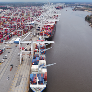
Darien and Port of Savannah, Georgia
Time Frame:
August-December 2013
Summary
Coastal Georgia is a diverse region encompassing approximately 100 miles and housing greater than half a million people in six counties. It contains some of Georgia’s oldest and most historic cities, some of which have grown into major economic engines.
The working waterfronts of the Georgia coast live within an environmental, cultural, and economic system that connects them all. These waterfronts are home to various waterfront industries at different scales including international container shipping, fishing, and shrimping, and tourism that benefits from the areas natural beauty and heritage.
Transferability
While the research and recommendations in this report are specifically based on two working waterfronts, the communities are of varied sizes, with differing advantages and disadvantages. These studies can be modified to address other coastal communities, as all of Georgia’s coastal towns have an economic reliance on the water surrounding them.
Best Practices:
- This case highlights economic studies using a blueprint focused on two different sites to examine how sea level rise affected each site.
- One site is one of the country’s largest container terminals and is a major economic engine for the state, and the second site was a small, coastal town.
- Impacts on each site were analyzed as each site demanded different approaches.
- Involving key stakeholders – including citizens, businesses, agency, and institutional representatives, and elected and appointed officials – throughout the entire planning process
Full Case Study Description
Background
Through research driven process, the Blueprints team (composed of Georgia Conservancy staff, instructor Jason Chernock and the Georgia Institute of Technology graduate City and Regional Planning studio) researched some of the major economic forces in two distinct places on the Georgia Coast, and how these will be impacted by rising seas. Sea level rise threatens businesses and vital infrastructure in ways that can impact affect Georgia’s economic vitality. Waterfront communities need to plan for impacts related to sea level rise, sooner rather than later. By planning now, communities can protect their livelihoods and treasures with a minimal cost or social disruption compared to acting when threats are imminent.
The Georgia Conservancy utilized a process known as “Blueprints for Successful Communities (Blueprints)”; a community design program. The process utilizes a community-based approach to sustainable planning and design. It involves citizens, businesses, agency and institutional representatives, and elected and appointed officials throughout the planning process. The team conducted data collection within the communities and developed recommendations that form the basis of the final report and will be utilized in the future to educate stakeholders and advance this knowledge.
Goal
To examine the effects of Sea Level rise on two waterfront communities’ economy. The Port of Savannah is a major economic engine for state, the city of Darien — which is the second study site — is a small, coastal town. Research into the economic impacts of sea level rise are lacking because the analysis captures relationships that remain hidden from other perspectives.
Challenges
The Georgia coast is home to some of the state’s oldest and most historic cities. Since the mid-1930s, the National Oceanic and Atmospheric Administration have documented a sustained trend of sea levels rising by 2.98 millimeters per year. Sea level rise threatens small and large businesses, vital infrastructure, and individuals along the coast in ways that will affect Georgia’s future economic vitality. Small businesses and economically disadvantaged households may have fewer resources to respond to inundation creating a disproportionate impact. Certain industries such as fishing, and tourism depend on the coast’s natural resources. In Darien the economy is heavily depend on these industries along with residential real estate increasing it vulnerability to sea level rise compared to larger port cities.
Actions
Both the Port of Savannah and the city of Darien will be impacted based on what is of value to them and threats may vary in severity attesting to fundamental differences between the two sites.
The Blueprints team collected data within the communities to produce maps and outputs; stakeholder interviews and site visits; as well as a set of conclusions and draft recommendations for stakeholders’ considerations. These recommendations form the basis of this report and will be utilized in the upcoming years to educate stakeholders and advance this knowledge.
The Blueprints process was directed and managed by the Georgia Conservancy. Technical support for the project was provided by Jason Chernock and a studio made up of graduate students in Georgia Tech’s City and Regional Planning program. The Working Waterfronts Blueprints for Successful Communities began in the summer of 2013 with data collection and project coordination and preparation. From August to December 2013, the research-based work occurred. From December to February 2013-2014, the Georgia Conservancy compiled, edited, and added to the planning studio’s work to create this final report, which was published in the fall of 2014.
In 2012, the Georgia Conservancy sponsored a studio by graduate students in the School of City and Regional Planning at the Georgia Institute of Technology to investigate the potential impacts of sea level rise in three coastal counties and to detail adaptation opportunities. The studio found that one meter of sea level rise would inundate nearly one third of the three-county studio area, with a disproportionate impact on parks and conservation land, particularly wetland areas. The team also found significant inundation of residential and waterfront commercial properties, inundation of 13 miles of state and national highways, and the flooding of railroads serving the Port of Savannah, one of the nation’s largest container ports. The Georgia Conservancy commissioned the present studio to expand upon the past studio’s work on the Georgia coast, particularly addressing sea level rise’s economic impacts on the coast and the ripples of this region- and state-wide.
The Blueprints team analyzed economic impacts on each site, taking different approaches depending on economic characteristics. Whereas the research team analyzed the Port of Savannah using a traditional economic impact study to measure the effects of a port shutdown, it approached the city of Darien entirely differently, conducting in-depth industry studies to draw connections between sea level rise and local livelihoods. Each methodology was chosen based on site-specific characteristics, such as industry makeup, economic scale, and available data.
Future
The Georgia Conservancy will continue to share this information with thought leaders on the coast and work to make the policy and planning changes to better community adaptability to sea level rise and its potential impacts.
Key Partners:
- The Georgia Conservancy worked with the Georgia Port Authority and elected officials in the City of Darien to convey report findings and work through impending sea level rise related issues.
- Georgia’s Conservancy work was not possible without support from The Home Depot Foundation, Gulfstream and the Ray C. Anderson Foundation
- Clark Alexander at the Skidaway Institute of Oceanography in Savannah.
- Other partners include elected officials, residents, industry, community planners and other stakeholders on the coast
References
Georgia Conservancy, Working Waterfronts: Economic Impacts of Sea Level Rise on Georgia’s Coast, 2013.
https://www.georgiaconservancy.org/blueprints/slr/economicimpacts